(Tuesday morning)
It's funny that when we first arrived in Ushuaia a little more than a week ago, it really did seem like the end of the world, as they advertise themselves. However, now that we have been to Antarctica, it seems like we are back in civilization.
It's about 50 degrees here, but just a quick transfer and we'll be back on a plane, 3 ½ hours to Buenos Aires, where it's supposed to be a hot and humid 87 degrees.
Wednesday, January 12, 2011
Cape Horn – Revenge of “the Drake”
By Saturday night, we were passing by the South Shetland Islands and back into the Drake Passage. This time, “the Drake” is living up to its reputation. Yesterday, we rolled along with 8-10 foot ocean swells. Thankfully, the seas died down overnight, but early this morning, ocean swells, wind and waves began to build. We are now about three hours from Cape Horn, with swells of 20-30 feet and winds near 40 knots.
One of our fellow passengers had been claiming to have missed the opportunity to “experience the Drake.” Well we're experiencing it now. The crew is claiming to have recorded gusts of 100 knots. You obviously can't go on deck in these conditions, so we have no pictures of these conditions, but if you watched “The Perfect Storm,” just take it down a couple of notches, throw in some confused waves as we near land, and you'll have the idea. A few members of our group have sequestered themselves in their rooms... not the best idea... I'm hanging out in a lounge near the middle of the ship. Think of it as a seesaw. Where you really want to be is in the middle.
Wait... Land Ho!
Weddell Sea and Antarctic Sound – Tabular Icebergs
After our swim, we ghosted out of Antarctica Sound amidst some huge tabular icebergs. Since we are (just barely) on the Eastern side of the Antarctic Peninsula, we are near the edge of the Weddell Sea, which is mostly frozen over. I believe this starts with sea ice, and then snow builds up and compresses in a glacier-like way, creating an “ice shelf” that is flat like a table. In the Spring and summer, large chunks of the “table” break off to form these “tabular” (table-like) icebergs.
Did I say large? The sizes actually range from large to huge to gargantuan to mammoth. According to Wikipedia, the largest iceberg on record was an Antarctic tabular iceberg of over 12,000 sq mi, 208 miles long and 60 miles wide, and they can reach up to 550 feet out of the water. And keep in mind, only a little more than 10% is above the surface.
Here's a shot of one that we went past. I believe it was about ¼ mile long, and not that far from where we swam:

Sunday, January 9, 2011
Touchdown in Antarctica Sound!
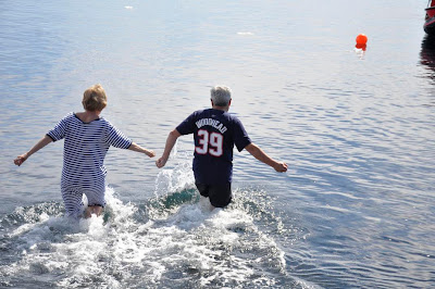
The day was perfect... 41 degrees and sunny... the water was crystal clear and 34 degrees... bergy bits all around... no current, so swimming had been approved by the excursion leader... I had my inspirational Danny Woodhead Patriots shirt on... Melanie had worn her borrowed bathing suit on... we're both nervous but determined... no excuses... no turning back...

Our Antarctica Swimming Club Certificates have been secured. Here are some other pictures leading up to the big moment above:

Melanie looking adorable in a borrowed traditional Antarctic swimsuit

Yes, those are iceberg "bergy bits" in the water
"No turning back"

"Oh God, I can't believe I'm doing this."

Melanie enjoys the moment of truth

Our Antarctica Swimming Club Certificates have been secured. Here are some other pictures leading up to the big moment above:


Brown Bluff and Antarctica Sound
We awoke on Saturday to another beautiful day, but VERY different ice conditions. Overnight, we had traveled northeast up the western side of the Antarctic Peninsula, and back down the very first part of the eastern side. On the eastern side, there are huge ice shelves, that break off into huge “tabular” icebergs. Some have almost perfect right angled sides and corners , that makes them look like mammoth one story buildings.
Combined with the regular bergs and bergy bits, we had to pick our way very slowly to our landing spot off the Taburin Peninsula, and a large cooked lava volcanic mound called Brown Bluff.
Brown Bluff is the home to over 20,000 mating pairs of Adelie penguins, and 250 or so pairs of gentoos. Although the area is pretty large, prime penguin real estate is at a premium here. Additionally, the Adelies are generally more aggressive than the other breeds we've seen, so in our short time by the rookery, we observed some pretty good fights, one “play date” gone bad (the parents had to step in), an eviction (where one poor guy got chased right out of the rookery). Any penguin walking to the shore between other nests earns a “stay away” peck from each nest occupant he goes past.

Two Adelie Siblings, or perhaps a "Play Date"
It was also fun to watch groups of penguins waddling along the shore to a certain spot, never the same spot as other groups. At some point, each group would stop, stand around for a minute, and then psych one another up with some penguin motivational cheers, and then into the Antarctic Sound, one by one.

A Group of Adelies Heading for their "Launch Zone"

"OK, Stop Here - This is the Spot."

"Geronimo!!!!"
But now it was time for our own motivational encouragement. It was time for Melanie and I to join the Antarctic Swim Club. It's now or never....
Combined with the regular bergs and bergy bits, we had to pick our way very slowly to our landing spot off the Taburin Peninsula, and a large cooked lava volcanic mound called Brown Bluff.
Brown Bluff is the home to over 20,000 mating pairs of Adelie penguins, and 250 or so pairs of gentoos. Although the area is pretty large, prime penguin real estate is at a premium here. Additionally, the Adelies are generally more aggressive than the other breeds we've seen, so in our short time by the rookery, we observed some pretty good fights, one “play date” gone bad (the parents had to step in), an eviction (where one poor guy got chased right out of the rookery). Any penguin walking to the shore between other nests earns a “stay away” peck from each nest occupant he goes past.

It was also fun to watch groups of penguins waddling along the shore to a certain spot, never the same spot as other groups. At some point, each group would stop, stand around for a minute, and then psych one another up with some penguin motivational cheers, and then into the Antarctic Sound, one by one.


But now it was time for our own motivational encouragement. It was time for Melanie and I to join the Antarctic Swim Club. It's now or never....
Saturday, January 8, 2011
Wilhelmina Bay
On Friday afternoon, there was no landing scheduled, just a “ship tour” around the bay. This bay was prime whaling territory and there were plenty of humpbacks around.
As we left the bay, our attention was directed to a hundred year old wreck near the bay entrance. No-one was using the telescope in the observation lounge so I took a peek at the wreck. To my shock, there were two people standing on a huge snowbank on the shoreline near the wreck. They were easily visible (at least in the telescope) due to their bright clothing. How strange it seemed to see people on their own outside any tourist zone. We had seen a sailboat motoring along earlier, so I assume it was those intrepid cruisers I was seeing in the telescope.
As a sailor myself, I like to read about people who have thrown off the shackles of civilization and sailed off “over the horizon.” I have even met some folks who have done it. But the destination for most is the Caribbean or South Pacific. The cruisers around Antarctica are the hard core cruisers, folks who don't mind enduring some hardships (such as the Drake Passage) to live the adventure. We have seen a few sailboats around since arriving here. I admire these people very much, but following them is not on my “bucket list.” Pass the margaritas, please :-) Rob
Almirante Brown – Body Surfing Down the Mountain
On Friday Morning, we stopped at Almirante Brown, a closed Argentinian base with an interesting history. Seven researchers were assigned here in the early 1980s, but after serving a year here, the Argentinian government told them to stay one more year as they didn't have the funds to bring them home. When this happened A SECOND TIME, in 1984, the station's doctor went “slightly mad” and burned the station down, turning their return trip into a rescue ... maybe he wasn't so mad after all.
This was our first landing on the Antarctic continent... all previous landings have been islands. We were hoping to swim here also, but the current here was also too strong... the launches had trouble loading/unloading both at the ship and at the landing site.
We're almost “penguined out,” so we decided to climb the hill and body surf down in the snow. I have given up taking pictures because we have such good photographers, with such great equipment, in our group. But I continue to bring the iPhone for some quick movies. This time, I got Melanie body-sliding down the slope. For this blog, the pictures will have to do.

The "mountain" as seen from the ship

The "mountain" as seen from the bottom

Melanie on her way down

Happy she made it

Oh yes, I went too
On a personal note, a big, big Antarctic “happy birthday” to our second-born daughter Tara. We had a laugh (and were quite impressed) when our eight-year-old grandson Jack answered our birthday call. I said “Greetings from Antarctica!” ... Jack laughed, and without missing a beat, replied, “Hello from North America!” ... the kid is quick :-) Rob
This was our first landing on the Antarctic continent... all previous landings have been islands. We were hoping to swim here also, but the current here was also too strong... the launches had trouble loading/unloading both at the ship and at the landing site.
We're almost “penguined out,” so we decided to climb the hill and body surf down in the snow. I have given up taking pictures because we have such good photographers, with such great equipment, in our group. But I continue to bring the iPhone for some quick movies. This time, I got Melanie body-sliding down the slope. For this blog, the pictures will have to do.


On a personal note, a big, big Antarctic “happy birthday” to our second-born daughter Tara. We had a laugh (and were quite impressed) when our eight-year-old grandson Jack answered our birthday call. I said “Greetings from Antarctica!” ... Jack laughed, and without missing a beat, replied, “Hello from North America!” ... the kid is quick :-) Rob
Vernadsky Station
(Thursday Afternoon)
The afternoon landing was at Vernadsky Station, a “year round” base built by the Brits but later given to the Ukranians, who are doing a lot of measurements of the ozone layer. The tour was disappointing because we were in a large group and rarely heard what our guide was saying. But it was nice of them to give us tours at all, considering that in the Ukraine, they celebrate Christmas on January 6th... For them, it was Christmas day.
Some impressions... First, living conditions are very spartan in Antarctica, even on a “year round” base. Second, when living in close quarters with others, personal hygiene is very important (one man walked by me in the hall and I have to say I wouldn't want to spend an Antarctic winter anywhere near him). Thirdly, wintering in Antarctica leaves one with time on his hands. The Ukraines filled some of this time by building a still and we were treated to shots of their homemade vodka in their “lounge” at the end of our tour.
After the base tour, we were taken back to the ship the long way around in order to see a gigantic leopard seal up close and personal. He was basking on his personal iceberg, but our launch driver found a way to get his attention. He would pull up close and then rev the engine in reverse, and the seal would raise his head to look at us.
There were also four very brave penguins on the seal's berg, who found a spot above him and seemed to be keeping an eye on him ... a penguin version of an early warning system? One crept down a little too close and started sliding down the berg toward the seal. His panicky scramble to get back up on his perch was the comic moment of the day. Our tour guide Elizabeth caught this sequence... I'll post it here later.
One last point. Vernadsky's latitude is 65 degrees, 15 minutes South. This is our southernmost point but still almost 100 miles short of the Antarctic Circle... temptingly close, but the pack ice at Vernadsky just opened up in the past week. The Fram does have a cruise that goes farther but it is a two week cruise. Anyway, we have already experienced 21 hour days, and really no night... it's OK to head north now :-) Rob
Petermann Island – Ready, Willing, but not Able
(Thursday Morning)
It doubt that the weather gets much better than this in Antarctica. Our first landing was on Petermann Island. Lengthy walking to get to more penguins, so we climbed the first ridge and just enjoyed looking out at one of the many “iceberg alleys.” We were a little preoccupied anyway as we had worn our bathing suits, ready for our initiation into the Antarctic Swim Club ... Anya, the expedition director said the current was too strong ... as we say on our boat, “Safety first.”
Yes, I said “we.” Melanie shocked me when we got up this morning. She had borrowed a bathing suit, and was ready to swim with me. She has always had one up on me in that she has gone bungee jumping (in New Zealand), and I haven't ... And having visited the bridge that she jumped off, I can safely say I wouldn't have done it ... oh wait, I mean I would surely have done it if I had had the opportunity.
So dressed in extra layers (for a supply of dry clothes to sear after our dip), we trekked up a hillside in the 41 degree “heat.” I wasn't able to stand it for long, and at the top of the hill, started peeling layers off. Since layer I wanted to keep on was not the bottom one, I can now at least say I've been topless in Antarctica :-) Rob
The Lemaire Channel
(Thursday “Early” Morning)
This morning, the ship's loudspeakers woke us at 7 AM to let us know we were entering the Lemaire Channel, one of the scenic highlights of the trip. Melanie and I found a couple of lounge chairs in the front of the bow observation deck. It was beautiful as we glided through the channel in the morning light ... I was going to say early morning light, but as mentioned, the sun rose at 2:45 AM this morning.
Here are two shots of the channel:


Although we were snugly inside, I was reminded of the “I'm the king of the world!” scene in the movie Titanic. We are so blessed to be here.
Port Lockroy Photo Spectacular
(Wednesday Night)
Most of today has been cloudy, so we were very unaware of the towering mountains around us until, during dinner, the fog gradually began to lift and sunlit peaks began to appear on all sides of the ship. Here is what Port Lockroy (it's the island) looked like by about 9:30 PM:

And some other peaks around the ship:


Port Lockroy at almost 11 PM:

As I write this, midnight has just passed. When I checked a few minutes ago, the highest peaks around us still reflected some faint sunlight. Now it is finally gone, but there is still plenty of light. It's a bright dusk because there is so much white snow reflecting the dusky light. You can easily still make out colors, and the penguins are swimming around in the bay, going every which way. I wonder if the fishing is better at “night,” which is a relative term here, as it will probably not get too much darker... it's only 2 ½ hours to sunrise :-) Rob
Thursday, January 6, 2011
Port Lockroy - Almost Civilization
(Wednesday Afternoon)
By Antarctic standards, Port Lockroy is a thriving metropolis, boasting a museum with a gift shop that accepts credit cards... Melanie perked up when she heard this, making sure I brought my wallet... You can even mail postcards from Port Lockroy if you don't mind them taking six weeks or more to get home. It was nice, though strange, to be in a building here.
Port Lockroy is a former British station, but now there are just four workers (currently all women) who spend four months running the museum and gift shop for the benefit of the Antarctic Heritage Trust.
Although I remembered the credit cards, I forgot both my camera and iPhone here... I'm sure others snapped pictures of the buildings, but there was one point where I really wished I had the iPhone. Several gentoos began playing king of the mountain on a bergy bit floating near the nesting area, repeatedly jumping onto the berg's little “swim platform,” hanging on as others jumped up, and then diving back in, only to repeat the process over and over. It would have made a great iPhone movie.
Tonight at dinner, we saw the girls from the station on board. We are staying here until 4 AM, so they were invited aboard for dinner, and seemed ecstatic about it.
Cuverville Island's Gentoo Penguins
(Wednesday Morning)
Our first excursion today was at Cuverville Island, and it was all about the penguins who summer here. We had an hour on the island and spent a large part of watching one particular nesting area and in fact, one penguin in particular. He kept walking over to very near where we were standing, very carefully picking up rocks and twigs, rejecting many, and bringing his prize selections over to his mate, nested maybe twenty feet away. His mate could not have appeared less interested.
But our little hero aimed to please, and he repeatedly trekked back and forth, dropping his prizes at her side as, most of the time, she looked the other way. Finally, she stood up and moved some stones into the nest, which we took to be a gesture of acceptance of approval, and gave our little drama a happy ending. I have a little iPhone movie of this whole adventure, which obviously I can't upload from here, but here's a picture of the little guy having just returned back to his foraging spot. (Sorry he's sideways... I haven't figured out how to fix it yet)

Our Hero (Foreground) Between Foraging Trips
Cuverville was also interesting in the sheer number of icebergs and “bergy bits” that are around. Here's an iPhone pic looking across the bay we were anchored in. Our ship is just out of the picture toward the right.

Finally, Cuverville had more snow than Half Moon Island. By their sheer activity, the penguins have carved out trails going back and forth between the water and their nests. Here is a penguin waddling down one of these trails:


After the penguin show, we reboarded the Fram to head through the Neumeyer Channel to our afternoon destination. En route, we had to stop to avoid a group of orcas pursuing a penguin in search of a light lunch. The staff made sure everyone new about this because many of them had never seen this behavior on any previous cruises.
Our first excursion today was at Cuverville Island, and it was all about the penguins who summer here. We had an hour on the island and spent a large part of watching one particular nesting area and in fact, one penguin in particular. He kept walking over to very near where we were standing, very carefully picking up rocks and twigs, rejecting many, and bringing his prize selections over to his mate, nested maybe twenty feet away. His mate could not have appeared less interested.
But our little hero aimed to please, and he repeatedly trekked back and forth, dropping his prizes at her side as, most of the time, she looked the other way. Finally, she stood up and moved some stones into the nest, which we took to be a gesture of acceptance of approval, and gave our little drama a happy ending. I have a little iPhone movie of this whole adventure, which obviously I can't upload from here, but here's a picture of the little guy having just returned back to his foraging spot. (Sorry he's sideways... I haven't figured out how to fix it yet)

Cuverville was also interesting in the sheer number of icebergs and “bergy bits” that are around. Here's an iPhone pic looking across the bay we were anchored in. Our ship is just out of the picture toward the right.

Finally, Cuverville had more snow than Half Moon Island. By their sheer activity, the penguins have carved out trails going back and forth between the water and their nests. Here is a penguin waddling down one of these trails:


After the penguin show, we reboarded the Fram to head through the Neumeyer Channel to our afternoon destination. En route, we had to stop to avoid a group of orcas pursuing a penguin in search of a light lunch. The staff made sure everyone new about this because many of them had never seen this behavior on any previous cruises.
Wednesday, January 5, 2011
Better Pictures? Help is On the Way!
I keep forgetting to mention that our ship, the MV Fram, maintains a very nice blog, updated daily, chronicling our travels, complete with some EXCELLENT pictures taken daily by the ship's photographer.
Also, I have just found a connector so I can now upload some of the pictures we've been taking. And Elizabeth, our tour guide, has shared her pictures with us. Elizabeth is a professional photographer, so I expect the photo content on this blog will also greatly improve.
But the ship's blog is also fun and informative, accessible at http://mvfram.blogspot.com - Rob
A Bonus! Deception Island
(Tuesday Night)
Because we were running a little ahead of schedule, our ship had time to pull into Deception Island for a quick visit at about 10:30 PM Tuesday night. Since the sun did not set until 11:45 last night (!!!), there was enough light for sightseeing, but not very much for good looking pictures. But Deception Island is a rather gloomy, foreboding place so the dark pictures seem appropriate.
Deception Island is actually the rim (caldera) of an active volcano, which last erupted in the 1980s. Sailors plied these waters for 2-3 years before they realized that the caldera had an break in it, which allowed entrance to calm protected waters, which is how the island got its name.

The Entrance to Deception Island ... Easy to Miss
I guess they didn't realize the volcano was active, because a whaling station was built there in the beginning of the 19th century, but was buried in ash during an eruption, rebuilt, and then buried in ash again. So now it sits there under several feet of ash and looks for all the world like a great place to locate a horror movie.
Actually, Deception Island WAS the inspiration for a movie. In Jules Vernes' “20,000 Leagues under the Sea, Deception Island was the inspiration for Captain Nemo's home base.
We pulled in, snapped many pictures, backed out, and were on our way to tomorrow's adventures.
Because we were running a little ahead of schedule, our ship had time to pull into Deception Island for a quick visit at about 10:30 PM Tuesday night. Since the sun did not set until 11:45 last night (!!!), there was enough light for sightseeing, but not very much for good looking pictures. But Deception Island is a rather gloomy, foreboding place so the dark pictures seem appropriate.
Deception Island is actually the rim (caldera) of an active volcano, which last erupted in the 1980s. Sailors plied these waters for 2-3 years before they realized that the caldera had an break in it, which allowed entrance to calm protected waters, which is how the island got its name.

I guess they didn't realize the volcano was active, because a whaling station was built there in the beginning of the 19th century, but was buried in ash during an eruption, rebuilt, and then buried in ash again. So now it sits there under several feet of ash and looks for all the world like a great place to locate a horror movie.
Actually, Deception Island WAS the inspiration for a movie. In Jules Vernes' “20,000 Leagues under the Sea, Deception Island was the inspiration for Captain Nemo's home base.
We pulled in, snapped many pictures, backed out, and were on our way to tomorrow's adventures.
First Landfall – Half Moon Island
(Tuesday Afternoon)
By about 2:30 PM, we arrived at Half Moon Island and excitedly suited up for our first trip to shore. Half Moon Island is a tiny crescent shaped island situated in a channel between the much larger Livingston and Greenwich Islands. It is the home to a rookery of maybe 1,000 chinstrap penguins, some fur seals, and an Argentine scientific station.
By 3:15, we were setting foot on Half Moon's rocky beach. I think everyone in our group probably had a similar feeling of “Am I really doing this?” The penguins are a lot of fun to watch. They really are adorable, and you just want to help them as the struggle up to the rookery, but we obediently kept our distance, and as instructed in the morning, gave them the right of way.
As is known to happen in these parts, the weather began to go downhill in a hurry. By the time we were trudging to the far side of the island where some seals were hanging out, we were experiencing a pretty raw drizzle. We did see a couple of seals on the far side of the island, but they seemed pretty bored with us, and were just laying around, so we didn't stay long.
We were only allowed an hour on the island, and had been instructed that if anyone wanted to join the Antarctic Swim Club, the best time to do it would be just before our scheduled pickup. Then, swimmers would be afforded priority seating on the next Polar Cirkel launch to leave for our ship... a VERY understandable accommodation. A few in a group had been talking about going in the water, including our tour guide Elizabeth, but I really didn't take them seriously. The water temperature here is about 35 degrees.
To my shock, as we trekked across the ridge from the seal area, there was Elizabeth, rapidly disrobing to reveal a swimsuit. We hustled down the hillside, cameras at the ready, just in time to catch Elizabeth's swim (it's really a dunk but impressive nonetheless, considering where we are). Then, to my further shock, several others in our group did the same.
So now I'm thinking, if we get another chance, I just might try it. I put my hand in the water and it did not shock me as expected. I think when the wind is cold, and perhaps due to the freezing rain, the water did not feel as shockingly cold as I thought it would... and guys, I'm told that, um, everything returns to normal in at most 2-3 days :-) Rob
Signs of Life
(Tuesday Morning)
Our crew confirms today that this has been the smoothest crossing of the Drake Passage that they have ever experienced. Some passengers actually expressed some disappointment at this (!!!) So the main excitement this morning stemmed from all the signs of life that began appearing in the water. Little creatures skimming along the ocean's surface in successions of quick jumps. Sometimes in groups of up to ten at a time. Too small to be seals... you have to train your eyes on where the next jump may be, and when you are right, you can see that they are penguins.
Later, a huge bird lands and floats awkwardly on the water... our first albatross sighting.
Whales have been around since the Beagle Channel for those with a sharp eye, Melanie among them.
But I am getting ahead of myself. First, you have the cross “the convergence,” the place where the South Atlantic, or South Pacific, meet the Antarctic current that circles around Antarctica, and therefore the globe, at these latitudes. The convergence is a pretty well defined boundary, and the temperature of the water falls by several degrees when you cross it. We crossed the convergence last night near dusk, so this is our first daylight in the Antarctic Sea.
It is ironic that the colder water supports MORE life, but cool clear water is great for plankton, plankton is great for krill, and krill are the preferred menu item for penguins and many types of seals.
There is a lot of fog where the cold waters and warm waters meet, so the excitement on board this morning was limited mostly to the penguin show. So there was also time for our mandatory training for shore exploration parties. This training includes procedures for getting on and off the ship, what to wear and bring, and a lot about how to interact with the wildlife in a minimally invasive way. Most ships that ply these waters belong to the International Association of Antarctic Tour Operators, which has guidelines for shore excursions... all of which seemed quite sensible and helpful.
Right after the training, and just before lunch, the fog lifted and we spotted our first land, Roberts Island in the South Shetland Island chain. Lots of pictures were being taken, but I have a feeling the scenery will only get more spectacular from here. Mainly, we were just excited and happy that our first landfall, on Half Moon Island, would be about on schedule. :-) Rob
Monday, January 3, 2011
Traveling with Mary Sunshine
My dear wife Melanie is an amazing person in many ways. But even those of you who know her well may not realize that she possesses a strange and enviable gift of being able to control the weather, at least on trips we take together. For this, I call her “Mary Sunshine.”
I can't tell you the number of times we have traveled in the midst of dire forecasts and had the weather turn out just wonderful. One time, we took a quickie three day trip to Bermuda. On arrival, people at the airport kept telling us how awful the weather had been for the previous two weeks. After spending a glorious three days there, we later met up with some people who had gone there right after us, who also reported rain every day.
I bring this up because it happened again in Ushuaia. Our local guide told us that they only have 3-4 days per month where they see the sunshine in Ushuaia. And the average high temperature is in the 50s. Our arrival day was sunny and maybe 60 and yesterday in Ushuaia was sunny and 72.
We had been prepared for the worst, a crossing of the feared Drake Passage, the northern edge of which claimed the life of many sailors attempting to round Cape Horn. As our home host in Ushuaia had told us, “sometimes you have to go through hell to get to paradise.” Our conditions are 15-20 knot moderate breezes and light to medium ocean swells. No dramamine taken and the swells just gently rock you to sleep.
I have no theology or philosophy to explain this... I'm just happily reporting the facts :-) Rob
Beyond the End of the World
(Sunday Night)
If Ushuaia, was really the end of the world, where are we now? As we travel west out of the Beagle Channel, we are passing one more town, Puerto Williams, on the south side of the channel. There are only about 2,000 residents here, and it is a town, not a city, but of course the Chileans have their own claim of being the southernmost TOWN in the world.

The TOWN of Puerto Williams, Chile
Chile and Argentina do not have the best of relations, and much of the land in this area is disputed. For example, Chile lays claim to half of the island of Tierra del Fuego. Even though nobody lives on the Chilean half, we passed a border police building on yesterday's tour.
Also, the island of Cabo de Hornos (Cape Horn) is in Chile, so only Chilean flagged ships are allowed to disembark there... a disappointment to this sailor, as to a sailor, a trip to Cape Horn is a bit like a pilgrimage to Mecca.
So this “southernmost” dispute seems a bit silly, but it did remind me of a tour we took in Key West, FL one time, where they claim to be the southernmost point in the U.S.... the guide started having fun with this, pointing out the southernmost mailbox, the southernmost dumpster, etc.
Can't we all just get along? :-) Rob
If Ushuaia, was really the end of the world, where are we now? As we travel west out of the Beagle Channel, we are passing one more town, Puerto Williams, on the south side of the channel. There are only about 2,000 residents here, and it is a town, not a city, but of course the Chileans have their own claim of being the southernmost TOWN in the world.

Chile and Argentina do not have the best of relations, and much of the land in this area is disputed. For example, Chile lays claim to half of the island of Tierra del Fuego. Even though nobody lives on the Chilean half, we passed a border police building on yesterday's tour.
Also, the island of Cabo de Hornos (Cape Horn) is in Chile, so only Chilean flagged ships are allowed to disembark there... a disappointment to this sailor, as to a sailor, a trip to Cape Horn is a bit like a pilgrimage to Mecca.
So this “southernmost” dispute seems a bit silly, but it did remind me of a tour we took in Key West, FL one time, where they claim to be the southernmost point in the U.S.... the guide started having fun with this, pointing out the southernmost mailbox, the southernmost dumpster, etc.
Can't we all just get along? :-) Rob
Ushuaia - “The End of the World”
Well, it turns out nobody liked my idea of calling Ushuaia “Malos Aires.” Besides, the aires were not at all malos... the weather in fact was beautiful. And they already have a pretty good nickname... “Fin del Mundo,” or “The End of the World.” Ushuaia is the southernmost city in the world.
Ushuaia does have that “last outpost” kind of feeling. It is still being settled, much like the old West in the United States. The government initially owned all the land. Settlers come in, find a nice piece of land, and start to build a a home. Later on, government representatives come around and negotiate a price and payment plan.
This system does have its down side. On our one night in Ushuaia, we had dinner in the home of a local couple, who described how it is not unusual to wake up in the morning and find someone in a tent, squatting in your back yard, ready to start building. It is imperative to fence in your property, once you have bought it from the government... but our hosts were unhappy about the fact that they can no longer just hike up the mountain. Now they encounter all kinds of fences.
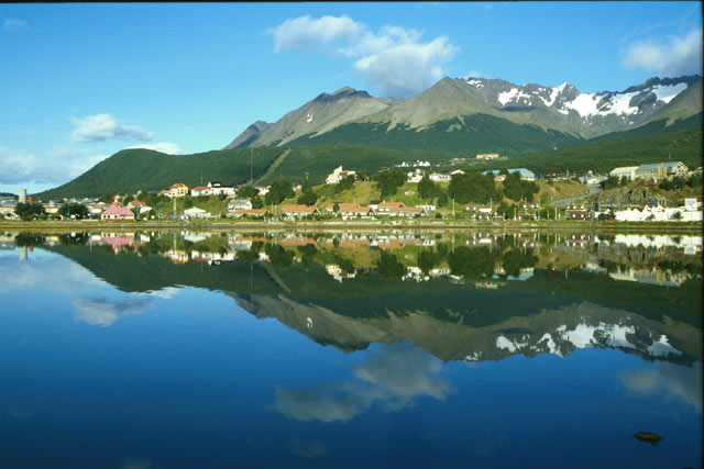
Ushuaia is located on the Beagle Channel, one of two major “shortcuts” for ships traveling between the Atlantic Ocean and the Pacific Ocean. The other passage, perhaps better known, is called the Strait of Magellan. Our local tour included a trip into the nearby Tierra del Fuego National Park. Tierra del Fuego is the name of the island we are on. It literally means “Land of Fire,” as the islands in this area are volcanic. The tour included a couple of great picture stops. I can't upload from the camera or cell phone right now, but here are a couple of public domain photos from Google images.

The City of Ushuaia

The Beagle Channel from Tierra del Fuego Nat'l Park
All of this, of course, is prelude to setting sail for Antarctica, which happens tonight (Sunday)
Ushuaia does have that “last outpost” kind of feeling. It is still being settled, much like the old West in the United States. The government initially owned all the land. Settlers come in, find a nice piece of land, and start to build a a home. Later on, government representatives come around and negotiate a price and payment plan.
This system does have its down side. On our one night in Ushuaia, we had dinner in the home of a local couple, who described how it is not unusual to wake up in the morning and find someone in a tent, squatting in your back yard, ready to start building. It is imperative to fence in your property, once you have bought it from the government... but our hosts were unhappy about the fact that they can no longer just hike up the mountain. Now they encounter all kinds of fences.
Ushuaia is located on the Beagle Channel, one of two major “shortcuts” for ships traveling between the Atlantic Ocean and the Pacific Ocean. The other passage, perhaps better known, is called the Strait of Magellan. Our local tour included a trip into the nearby Tierra del Fuego National Park. Tierra del Fuego is the name of the island we are on. It literally means “Land of Fire,” as the islands in this area are volcanic. The tour included a couple of great picture stops. I can't upload from the camera or cell phone right now, but here are a couple of public domain photos from Google images.

All of this, of course, is prelude to setting sail for Antarctica, which happens tonight (Sunday)
Saturday, January 1, 2011
Off to "Malos Aires"
Buenos Aires was named by Spanish sailors who sailed in this vicinity in the 16th century. Literally, it means "good airs," or in sailing terms, "fair winds."
As you go south from here, the "airs" get progressively worse, culminating in the foul and fierce winds that frequent the area around Cape Horn. "Rounding the Horn" was always a challenge, especially in the clipper ships of the day, which did not point (sail at a tight angle into the wind) as well as sailboats of today.
So today, we fly to the closest city to Cape Horn, the small Argentinian city of Ushuaia, which also has the distinction of being the southernmost city in the world. Ushuaia is subject to the fierce weather common to the region, hence my nickname "Malos Aires," meaning "foul winds.".
I don't think the chamber of commerce will go for it though :-) Rob
Subscribe to:
Posts (Atom)