Wednesday, January 5, 2011

A Bonus! Deception Island

(Tuesday Night)

Because we were running a little ahead of schedule, our ship had time to pull into Deception Island for a quick visit at about 10:30 PM Tuesday night. Since the sun did not set until 11:45 last night (!!!), there was enough light for sightseeing, but not very much for good looking pictures. But Deception Island is a rather gloomy, foreboding place so the dark pictures seem appropriate.

Deception Island is actually the rim (caldera) of an active volcano, which last erupted in the 1980s. Sailors plied these waters for 2-3 years before they realized that the caldera had an break in it, which allowed entrance to calm protected waters, which is how the island got its name.
The Entrance to Deception Island ... Easy to Miss

I guess they didn't realize the volcano was active, because a whaling station was built there in the beginning of the 19th century, but was buried in ash during an eruption, rebuilt, and then buried in ash again. So now it sits there under several feet of ash and looks for all the world like a great place to locate a horror movie.

Actually, Deception Island WAS the inspiration for a movie. In Jules Vernes' “20,000 Leagues under the Sea, Deception Island was the inspiration for Captain Nemo's home base.

We pulled in, snapped many pictures, backed out, and were on our way to tomorrow's adventures.

First Landfall – Half Moon Island

(Tuesday Afternoon)

By about 2:30 PM, we arrived at Half Moon Island and excitedly suited up for our first trip to shore. Half Moon Island is a tiny crescent shaped island situated in a channel between the much larger Livingston and Greenwich Islands. It is the home to a rookery of maybe 1,000 chinstrap penguins, some fur seals, and an Argentine scientific station.

By 3:15, we were setting foot on Half Moon's rocky beach. I think everyone in our group probably had a similar feeling of “Am I really doing this?” The penguins are a lot of fun to watch. They really are adorable, and you just want to help them as the struggle up to the rookery, but we obediently kept our distance, and as instructed in the morning, gave them the right of way.

As is known to happen in these parts, the weather began to go downhill in a hurry. By the time we were trudging to the far side of the island where some seals were hanging out, we were experiencing a pretty raw drizzle. We did see a couple of seals on the far side of the island, but they seemed pretty bored with us, and were just laying around, so we didn't stay long.

We were only allowed an hour on the island, and had been instructed that if anyone wanted to join the Antarctic Swim Club, the best time to do it would be just before our scheduled pickup. Then, swimmers would be afforded priority seating on the next Polar Cirkel launch to leave for our ship... a VERY understandable accommodation. A few in a group had been talking about going in the water, including our tour guide Elizabeth, but I really didn't take them seriously. The water temperature here is about 35 degrees.

To my shock, as we trekked across the ridge from the seal area, there was Elizabeth, rapidly disrobing to reveal a swimsuit. We hustled down the hillside, cameras at the ready, just in time to catch Elizabeth's swim (it's really a dunk but impressive nonetheless, considering where we are). Then, to my further shock, several others in our group did the same.

So now I'm thinking, if we get another chance, I just might try it. I put my hand in the water and it did not shock me as expected. I think when the wind is cold, and perhaps due to the freezing rain, the water did not feel as shockingly cold as I thought it would... and guys, I'm told that, um, everything returns to normal in at most 2-3 days :-) Rob

Signs of Life

(Tuesday Morning)

Our crew confirms today that this has been the smoothest crossing of the Drake Passage that they have ever experienced. Some passengers actually expressed some disappointment at this (!!!) So the main excitement this morning stemmed from all the signs of life that began appearing in the water. Little creatures skimming along the ocean's surface in successions of quick jumps. Sometimes in groups of up to ten at a time. Too small to be seals... you have to train your eyes on where the next jump may be, and when you are right, you can see that they are penguins.

Later, a huge bird lands and floats awkwardly on the water... our first albatross sighting.

Whales have been around since the Beagle Channel for those with a sharp eye, Melanie among them.

But I am getting ahead of myself. First, you have the cross “the convergence,” the place where the South Atlantic, or South Pacific, meet the Antarctic current that circles around Antarctica, and therefore the globe, at these latitudes. The convergence is a pretty well defined boundary, and the temperature of the water falls by several degrees when you cross it. We crossed the convergence last night near dusk, so this is our first daylight in the Antarctic Sea.

It is ironic that the colder water supports MORE life, but cool clear water is great for plankton, plankton is great for krill, and krill are the preferred menu item for penguins and many types of seals.

There is a lot of fog where the cold waters and warm waters meet, so the excitement on board this morning was limited mostly to the penguin show. So there was also time for our mandatory training for shore exploration parties. This training includes procedures for getting on and off the ship, what to wear and bring, and a lot about how to interact with the wildlife in a minimally invasive way. Most ships that ply these waters belong to the International Association of Antarctic Tour Operators, which has guidelines for shore excursions... all of which seemed quite sensible and helpful.

Right after the training, and just before lunch, the fog lifted and we spotted our first land, Roberts Island in the South Shetland Island chain. Lots of pictures were being taken, but I have a feeling the scenery will only get more spectacular from here. Mainly, we were just excited and happy that our first landfall, on Half Moon Island, would be about on schedule. :-) Rob

Monday, January 3, 2011

Traveling with Mary Sunshine

My dear wife Melanie is an amazing person in many ways. But even those of you who know her well may not realize that she possesses a strange and enviable gift of being able to control the weather, at least on trips we take together. For this, I call her “Mary Sunshine.”

I can't tell you the number of times we have traveled in the midst of dire forecasts and had the weather turn out just wonderful. One time, we took a quickie three day trip to Bermuda. On arrival, people at the airport kept telling us how awful the weather had been for the previous two weeks. After spending a glorious three days there, we later met up with some people who had gone there right after us, who also reported rain every day.

I bring this up because it happened again in Ushuaia. Our local guide told us that they only have 3-4 days per month where they see the sunshine in Ushuaia. And the average high temperature is in the 50s. Our arrival day was sunny and maybe 60 and yesterday in Ushuaia was sunny and 72.

We had been prepared for the worst, a crossing of the feared Drake Passage, the northern edge of which claimed the life of many sailors attempting to round Cape Horn. As our home host in Ushuaia had told us, “sometimes you have to go through hell to get to paradise.” Our conditions are 15-20 knot moderate breezes and light to medium ocean swells. No dramamine taken and the swells just gently rock you to sleep.

I have no theology or philosophy to explain this... I'm just happily reporting the facts :-) Rob

Beyond the End of the World

(Sunday Night)

If Ushuaia, was really the end of the world, where are we now? As we travel west out of the Beagle Channel, we are passing one more town, Puerto Williams, on the south side of the channel. There are only about 2,000 residents here, and it is a town, not a city, but of course the Chileans have their own claim of being the southernmost TOWN in the world.

The TOWN of Puerto Williams, Chile


Chile and Argentina do not have the best of relations, and much of the land in this area is disputed. For example, Chile lays claim to half of the island of Tierra del Fuego. Even though nobody lives on the Chilean half, we passed a border police building on yesterday's tour.

Also, the island of Cabo de Hornos (Cape Horn) is in Chile, so only Chilean flagged ships are allowed to disembark there... a disappointment to this sailor, as to a sailor, a trip to Cape Horn is a bit like a pilgrimage to Mecca.

So this “southernmost” dispute seems a bit silly, but it did remind me of a tour we took in Key West, FL one time, where they claim to be the southernmost point in the U.S.... the guide started having fun with this, pointing out the southernmost mailbox, the southernmost dumpster, etc.

Can't we all just get along? :-) Rob

Ushuaia - “The End of the World”

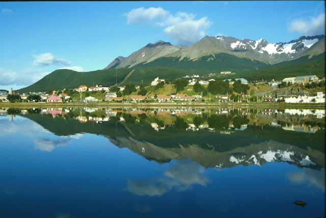
Well, it turns out nobody liked my idea of calling Ushuaia “Malos Aires.” Besides, the aires were not at all malos... the weather in fact was beautiful. And they already have a pretty good nickname... “Fin del Mundo,” or “The End of the World.” Ushuaia is the southernmost city in the world.

Ushuaia does have that “last outpost” kind of feeling. It is still being settled, much like the old West in the United States. The government initially owned all the land. Settlers come in, find a nice piece of land, and start to build a a home. Later on, government representatives come around and negotiate a price and payment plan.

This system does have its down side. On our one night in Ushuaia, we had dinner in the home of a local couple, who described how it is not unusual to wake up in the morning and find someone in a tent, squatting in your back yard, ready to start building. It is imperative to fence in your property, once you have bought it from the government... but our hosts were unhappy about the fact that they can no longer just hike up the mountain. Now they encounter all kinds of fences.

Ushuaia is located on the Beagle Channel, one of two major “shortcuts” for ships traveling between the Atlantic Ocean and the Pacific Ocean. The other passage, perhaps better known, is called the Strait of Magellan. Our local tour included a trip into the nearby Tierra del Fuego National Park. Tierra del Fuego is the name of the island we are on. It literally means “Land of Fire,” as the islands in this area are volcanic. The tour included a couple of great picture stops. I can't upload from the camera or cell phone right now, but here are a couple of public domain photos from Google images.

The City of Ushuaia


The Beagle Channel from Tierra del Fuego Nat'l Park


All of this, of course, is prelude to setting sail for Antarctica, which happens tonight (Sunday)

Saturday, January 1, 2011

Off to "Malos Aires"

Buenos Aires was named by Spanish sailors who sailed in this vicinity in the 16th century. Literally, it means "good airs," or in sailing terms, "fair winds."

As you go south from here, the "airs" get progressively worse, culminating in the foul and fierce winds that frequent the area around Cape Horn. "Rounding the Horn" was always a challenge, especially in the clipper ships of the day, which did not point (sail at a tight angle into the wind) as well as sailboats of today.

So today, we fly to the closest city to Cape Horn, the small Argentinian city of Ushuaia, which also has the distinction of being the southernmost city in the world. Ushuaia is subject to the fierce weather common to the region, hence my nickname "Malos Aires," meaning "foul winds.".

I don't think the chamber of commerce will go for it though :-) Rob